7 results
Mass changes of the Greenland and Antarctic ice sheets and shelves and contributions to sea-level rise: 1992–2002
-
- Journal:
- Journal of Glaciology / Volume 51 / Issue 175 / 2005
- Published online by Cambridge University Press:
- 08 September 2017, pp. 509-527
-
- Article
-
- You have access
- HTML
- Export citation
Greenland ice sheet mass balance: distribution of increased mass loss with climate warming; 2003–07 versus 1992–2002
-
- Journal:
- Journal of Glaciology / Volume 57 / Issue 201 / 2011
- Published online by Cambridge University Press:
- 08 September 2017, pp. 88-102
-
- Article
-
- You have access
- HTML
- Export citation
An assessment of the regional distribution of the oxygen-isotope ratio in northeastern canada
-
- Journal:
- Annals of Glaciology / Volume 25 / 1997
- Published online by Cambridge University Press:
- 20 January 2017, pp. 214-219
-
- Article
-
- You have access
- HTML
- Export citation
Areal distribution of the oxygen-isotope ratio in Antarctica: an assessment based on multivariate models
-
- Journal:
- Annals of Glaciology / Volume 25 / 1997
- Published online by Cambridge University Press:
- 20 January 2017, pp. 153-158
-
- Article
-
- You have access
- HTML
- Export citation
Accumulation in Antarctica and Greenland derived from passive-microwave data: a comparison with contoured compilations
-
- Journal:
- Annals of Glaciology / Volume 21 / 1995
- Published online by Cambridge University Press:
- 20 January 2017, pp. 123-130
-
- Article
-
- You have access
- HTML
- Export citation
Areal distribution of the oxygen-isotope ratio in Greenland
-
- Journal:
- Annals of Glaciology / Volume 25 / 1997
- Published online by Cambridge University Press:
- 20 January 2017, pp. 208-213
-
- Article
-
- You have access
- HTML
- Export citation
The area of ice shelves in Antarctica*
-
- Journal:
- Polar Record / Volume 12 / Issue 77 / May 1964
- Published online by Cambridge University Press:
- 27 October 2009, pp. 171-173
-
- Article
- Export citation
-
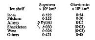
In Polar Record, Vol 11, No 75,1963, p 735, I. A. Suyetova made calculations of the area of Antarctica and of its major ice shelves based on published and unpublished material available up to 1961. Suyetova's estimate of the area of the ice shelves, excluding attached islands and ice rises, is 1–38 × 106 km2. In a study of the drainage systems of Antarctica (Giovinetto, 1963) the area of the ice shelves as defined above is estimated at (1·63 ± 0·30) × 106 km2. The latter estimate is based, except for the region of the Filchner Ice Shelf, on the more recent chart of Antarctica compiled by the American Geographical Society (1962; 1:3000000). The difference between the estimates of total ice shelf area cannot be explained entirely by the margin of error; there are some differences between the areas estimated for particular ice shelves which are significant: